You are currently browsing the category archive for the ‘earth sciences’ category.
I know.
(image source: veryaware.com)
Elsewhere, it’s cold. Go here and scroll quickly down below the frightening hotness to see today’s lowest recorded temps. Granted, most are in Antarctica, but not all.
I applied for an adjunct faculty position at Small Public College.
And made a very nice little red and blue wool bag.
And ate doughnuts!
Watching How the Earth Was Made instead, and trying to play this strange Tetris game. HtEWM is good, but I’d rather watch The Universe. They could keep showing the same episodes over and over; that would be fine. I guess the thing I really have against HtEWM is …it tries to sound doomy and urgent like Mega Disasters. No sense of humor. And they called the San Andreas Fault an “ugly scar.” The hell? That’s almost as bad as “shark-infested waters.” They freaking LIVE THERE. Come and whine about it when sharks start crawling up on the land.
The slideshow will be about opportunity cost, PPFs, diminishing marginal utility, and international trade. And Chapter 2 of Cod. In other words it’ll take about a hundred years. But I’ll break it up in July 2060 with this fun video I’ve used before of a HoHos eating contest. I’m too cheap to buy actual HoHos for four separate contests, and have no interest in HoHo vomit after a weekend of cat vomit. Poor little puma has to cut back. That’s what I do, I give people (and pumas) too much food, except for HoHos.
I was watching 10.5: Apocalypse just now, until attaining a point of temporary shite overload. The eruption of Bald Mountain in Idaho was mainly what I wanted out of this.

(Screenshot from trailer at imdb.com)
Well, Bald Mountain doesn’t look anything like that, but never mind! I started thinking about the pointy mountains I was sure, in my childhood, would erupt any day and kill me. There was one in particular, a pretty little pyramidal Wasatch foothill which had, to me, a suggestion of cinder cone but is not really a volcano at all. It loomed up beyond Fort Douglas; I can see it in my mind’s eye but can’t yet identify it from topo maps of the old neighborhood. I had my eye on that one all the time. As an eight-year-old I’d found The Day the World Ended lying around the house and read it in one sitting. The fer-de-lances gave me the worst nightmares, but the volcano fear and fascination have stayed with me for — wow! Forty years. And now I live closer to (what’s left of) a real volcano than ever before.
To do: cook something on a piece of this.
It comes from the Khewra Salt Mines in the foothills of Pakistan’s Salt Range. Within the mine’s tunnels is this little mosque made of salt bricks:

(source)
Recommended reading: “The Salt Range: Pakistan’s unique field museum of geology and paleontology,” by Shahid Jalil Sameeni
…”fault.” Get it?
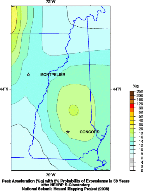
Why does the earth quake in New England?

Seismic hazard map (source)
My #1 earthquake so far. I was living in a nine-story apartment block in White Center, south of West Seattle. The first thing I noticed was a crackling noise around the window; then the building rolled like a ship. I crouched in a door frame, pounded on the floor and shouted “Stop it!” A girl pelted down the hall in her bare feet, wailing “It’s a earfquake!” Then everyone streamed into the parking lot. Many people sat in their cars for hours, frightened that somehow the disaster that had struck our sister city just days earlier had now come for us.
Palaeos.com: palaeontology, cladistics, geochronology.
Heard on VPR. James Wilson (1763-1835) was an Upper Valley dairy farmer who became interested in cartography. Captivated by a Dartmouth College exhibit of fine European globes, he started learning everything he needed to know to make his own, and became the first globe manufacturer in the U.S.

(source)
Mongolian: ereen, “colorful;” hot, “town,” as in Hohhot (“blue town”) and Ulan Hot (“red town”).
“To the northeast of Erenhot is a salt lake, Dabusan Nur, rich with salt and mirabilite (hydrated sodium sulfate)….”
But Dabusan Nur means “salt lake.”
Mirabilite earns its name!

(source)
is Windsor-Unadilla Variant-Agawam: Deep, nearly level to very steep, excessively drained and well drained, sandy and loamy soils formed in glacial outwash deposits. (Map .pdf here.)

Soil composition diagram (source). (Once as a volunteer reader for Recording for the Blind & Dyslexic I had to describe this thing in reasonable detail as it appeared in a textbook. Yikes!!)


